So you want to add stuff to this map?
The features shown on this map are all stored in a database created by OpenStreetMap, a community dedicated to mapping the whole world and sharing the data free from the normal copyright restrictions. Anyone can contribute to OpenStreetMap, and anyone can use the data in any way they like so long as they give credit to the community and share any changes they make under the same terms.
You are free to add anything you like to OpenStreetMap, including more renewable energy generators, recycling bins, community food growing spaces, car club parking bays, art galleries and all the other features we display here.
To add stuff to the map, you basically need to:
- Sign up to OpenStreetMap;
- Get out into your local area and note the features you want to add;
- Come back home, fire up an editor and add them in.
There are two golden rules to obey:
- You must not copy any information from other maps or other copyrighted materials - that includes things others have put onto Google Maps, and info on the council's web maps, for example;
- Only enter things that actually physically exist on the ground. For example, add a library but don't add a community group that meets there - OpenStreetMap isn't the place for that sort of information.
Introducing OpenStreetMap
OpenStreetMap can be a very confusing beast. Basically, at the heart of the project is a database holding all the map data that people work with.
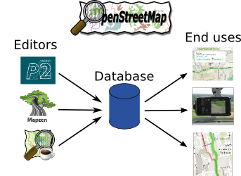
On the left there is a range of software packages people use to enter data into that database. Some tools work well on mobile phones, others are easy to use but limited in their power, and a few are very hard to learn but extremely powerful.
On the right, we have all sorts of interesting uses for the data. In the diagram you can see a major online mapping provider, a satnav device and a cycle journey planner all using OpenStreetMap.
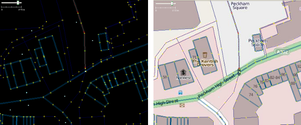
The data structure is quite simple. For simple features like bus stops, post boxes and cycle racks you have dots (called "nodes"). For linear features like roads, paths, buildings and parks you have lots of dots ("nodes") and they are joined up with lines ("ways"). You can see these below.
For every feature you add - whether a node or a way - you then add information (called "tags"). Each tag has a key and a value, key=value, for example:
- highway=primary (this is a primary highway, i.e. an A-road in the UK)
- name=Strand (this way is called Strand)
- maxspeed=30 mph (this way has a maximum speed restriction of 30 miles per hour))
Editors let you add and change these nodes and ways; data users take them and draw maps, plan journeys, etc.
...
Now you've got the basics sorted, head on to learn how to edit OpenStreetMap.